Last week, at Google I/O, the brand unveiled the next update for Google Maps. That showed off a new feature called Immersive View for Routes, which looks set to revolutionise the way we travel.
But that's not all. In their accompanying blog post, Google announced that the underlying API and 3D imaging is being made available to other developers.
That means that similar functionality could be coming to other apps and use-cases in the near future. I think that's a really exciting prospect. Here are three reasons why.
1. Immersive View for Routes
It would be easy to brush straight past this, but lets give some credit to Google here. The app at the centre of this innovation, Immersive View for Routes is going to completely change the way we get from A-to-B.
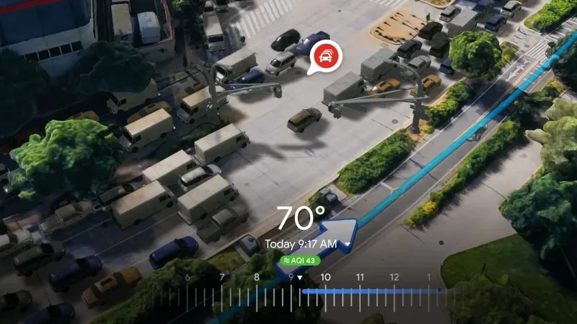
In a move that will resonate with any users who's ever followed the quickest route, only to find themselves wandering through a sketchy alleyway, Immersive View gives you a 3D preview of the route on offer. That's brilliant, especially for travelling to places you might be less familiar with. Users can check out their journey to make sure it's a safe route, and memorise landmarks and points of interest to make sure they're on the right path.
That's before we even get into the live traffic and weather updates, complete with their own graphics on screen. Those allow you to check things like air quality, and determine the best time to travel.
2. Renting property
As someone who has moved house more times than I can count, I feel well placed to say this technology could change the way we rent forever. Having moved to a new city pretty much every time, it can be really challenging to know where is good to move and where is safe.
Get all the latest news, reviews, deals and buying guides on gorgeous tech, home and active products from the T3 experts
US rental website, Rent.com, are already putting this technology to work in this setting. Using Google's API, they are able to offer an aerial view of a property in the surrounding neighbourhood, letting applicants make better decisions about where they choose to live.
3. Game maps
This one is a little more out there, but stay with me here. Google are letting their API and aerial imaging out to other developers. They show this being used to give detailed aerial views of cities, landmarks and national parks, to develop an interactive tour.
But what if those same base renders could be used to map out in-game locations? Large city frameworks could become much easier to build, and much more true-to-life.
Instead of playing Grand Theft Auto in Los Santos, users could find themselves driving through Los Angeles. Call of Duty maps based off real locations could add huge amounts of added detail and realism. It has the potential to create a seismic shift in these large map games.

Sam Cross is an award-winning journalist, with nine years of experience in the media industry. His work can be found in publications as diverse as Oracle Time, Metro and Last Word on Sports.
Sam is best known for all things luxurious – from exquisite watches to fine fragrances; the latest performance vehicles to intricate audio equipment, and more.
He’s often found travelling around the world to test new launches, complete with high-end backpacks and suitcases in tow. And when he’s not adding to his air miles, Sam can be found in front of a video camera, bringing his distinctive brand of storytelling to social media channels.
Sam also loves all things analogue, including listening to music on vinyl or cassette, and photography on vintage film cameras.