The Garmin eTrex 10 GPS certainly isn’t a new model from Garmin, but it has a variety of points that one of the best hiking GPS systems for the occasional user. Indeed, its combination of low price, rugged build and easy operation has made it an outdoor industry-standard backup device for emergencies. The very low RRP illustrates this – it’s almost hard to justify not having one. Read on for our full Garmin eTrex 10 GPS review.
- Complete your hiking kit: these are the best waterproof jackets
- ... and the best hiking boots
- Need something more feature-rich? Try one of the best outdoor watches
Garmin eTrex 10 GPS review: design and build
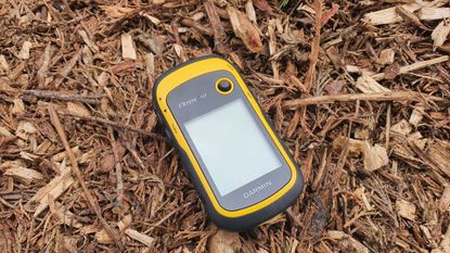
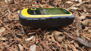
The Garmin eTrex 10 GPS design is simplicity itself - a rear battery cover conceals a pair of AA batteries, sealing shut with a D-ring closure that earns the unit an IPX7 waterproofing rating - that’s submersed in water at a depth of one meter, for 30 minutes. The rubberised surround contains the moulded-in up/down, menu, back and power buttons, and there’s a thumb-operated joystick above the mini 2.2” screen. The latter is monochrome-only, a factor in squeezing the claimed 25 hours operation out of those AAs, and is easily readable in most conditions as a result. The screen has a good backlight for low-light conditions, which is easily toggled up or down via the power button, but due to the monochrome screen it can stay off in the daytime, eking out those batteries still further.
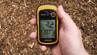
The best bit about the design is the size, which is perfectly judged to fit in the palm of your hand. Even wearing gloves, the controls fall to hand neatly and securely. There's no SD slot to add storage, so you’re stuck with the somewhat weedy 6MB of onboard storage, which is one of the weaker points of the device. There is a USB mini (not micro) port hidden at the back, so GPX files can be uploaded from a PC.
There’s a handy (if somewhat sobering) ‘man overboard’ function, which immediately creates a waypoint and then begins navigation back to that point, as well as arguably less useful functions including a calculator, stopwatch and a Hunting and Fishing function that surely nobody has ever used. A Sun and Moon function gives daylight hours and moon state, which is much more useful.
Garmin eTrex 10 GPS review: performance
There’s good news and bad news here, and on the former, satellite acquisition and position fixing are super-fast, especially if you have tweaked your settings to enable all satellite use. Garmin claims the eTrex series are the first-ever consumer-grade receivers that can track both GPS and GLONASS satellites simultaneously, which essentially adds an additional 24 satellites to the GPS constellation - very helpful indeed if speed is important to you.
The Garmin eTrex 10 GPS holds onto you well too, even under tree cover and in built up areas, thanks to the EGNOS-enabled GPS receiver and HotFix satellite prediction. Other good news is that uploading GPX files for paperless geocaching is supported, and has a dedicated menu item to make the process quick and easy.
Another useful tool is the differential compass, which updates fast enough for walking and hiking navigation, but can be a bit on the laggy side for trail running jaunts. With sections for speed, ETA, distance and time to the next waypoint, this is where you’ll spend most of your Garmin eTrex 10 GPS screen time. Marking waypoints is relatively straightforward, although the keyboard can be slightly faffy.
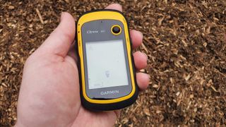
The bad news is the mapping. Garmin supplies the Garmin eTrex 10 GPS with a worldwide basemap, and basemap it is indeed. Waiting for the detail to load takes a very long time...till you realise there is no detail loading. Major landmarks like rivers and borders are present and correct, but navigating by them is more art than science.
However, as long as you’ve planned a route in Garmin’s Basecamp and uploaded it before, or are following waypoints you plotted on the outbound route, then there’s enough meat on the bone, but for live map-based navigation in the field, this is not the device you’re looking for.
Garmin eTrex 10 GPS review: specs
- Physical size: 2.1" x 4.0" x 1.3" (5.4 x 10.3 x 3.3 cm)
- Screen size: 1.4" x 1.7" (3.6 x 4.3 cm); 2.2" diag (5.6 cm)
- Display resolution: 128 x 160 pixels
- Display type: transflective, monochrome
- Weight: 5oz (141.7g) with batteries
- Battery type: 2 AA
- Battery life: 25 hours
- Water rating: IPX7
- Interface: Mini USB
- Memory: 6MB
- Waypoints: 1000
- Tracks: 100
- Routes: 50
Garmin eTrex 10 GPS review: alternatives to consider
As an entry level model, it’s easy to outstrip the Garmin eTrex 10 GPS – its eTrex siblings feature colour screens, more storage and helpful additions like an altimeter, in the case of the Garmin eTrex 32x. Equally, for more professional-level users the Garmin GPSMAP 65 range offers serious firepower for only a little more bulk. However, bear in mind that you’re more than doubling and then trebling the price of the little Garmin eTrex 10 to step up to those two examples respectively, so very much a case of horses for courses.
Garmin eTrex 10 GPS review: verdict
With the major caveat that there are far more powerful competitors out there, the Garmin eTrex 10 GPS is a top-class little GPS system, ideal for the beginner or occasional user. Satellite acquisition is fast, thanks to Garmin’s ingenious engineering, and for keen geocaching-aficionados it’s a perfect rugged alternative to a smartphone. As a backup emergency device it is perfect, and as a low-investment entry point into a market that can get very pricey, it’s a solid choice.
The downside to that is often quite basic functionality, especially visible in the basemap and mapping functions, which are minimalist at best. Storage is also painfully small, which limits expedition-style functionality quite quickly.
