Many GPS apps exist to direct you from A to B on foot or by car. Most sports apps are there to go racing and track your performance. Komoot is rather different.
Sure, it can get you from A to B, but taking in C, D and E – and by a range of routes to suit you. It’s not about getting there fast, it’s about enjoying the journey, and finding new places.
Komoot is a cycling and hiking navigator that’s built for exploration, rather than the mundane day-to-day task of finding a location, or just racing to be ‘the fastest’.
Komoot: Route Planner

Komoot offers different routes for each way to explore
Such is the wealth of options that Komoot puts at your disposal, it’s actually quite hard to put it all down in one short feature, but here is the essence of Komoot.
You are in the great outdoors. Could be anywhere from the south Downs to Dartmoor. It could even be the suburbs of your home town, which you’ve always been meaning to explore.
Simply pick a start and end point, then choose your favoured mode of movement: road biking, mountain biking or hiking – some route also suggest other modes of movement such as trail running and gravel cycling, and yet more options, such as gravel biking, are coming soon.
Komoot will generate routes accordingly. Clearly, this will involve going by road for road biking, and largely off-road for MTB and hiking. What is immediately apparent is that the routes generated are all very different.
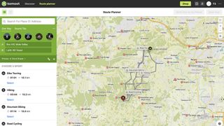
So let’s try a fairly gentle route from Box Hill to Leith Hill Tower.
One trip, three routes #1: cycle

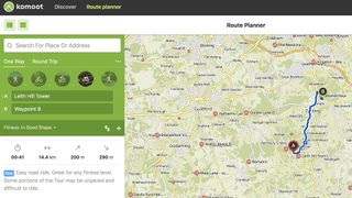
Komoot can take you the easy way…
Bike rides are the bread and butter of Komoot, with the option of bike touring – a mix of road and off-road – and road biking – self explanatory. Rides are given simple classifications for difficulty: light, moderate or heavy.
As you can see, the routes for your road and touring cycles are radically different from the ones suggested for MTB and hiking enthusiasts, even over this fairly short jaunt.
Naturally Komoot displays the distance and overall elevation of the ride. However it also breaks the trip down by road type and even road surface. That means you can see exactly how much asphalt, road, gravel and looser surfaces you’re going to be taking on. That’s a potentially invaluable feature, which you won’t find anywhere else.
However, you can also customise in a more personalised way. If you want to take in great views, plan in more uphill. Komoot lets you see the elevation of your route in detail, as well as a bird’s eye view.
One trip, three routes #2: MTB

…Komoot can also find you a more scenic and rugged ride
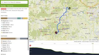
Okay, so mountain biking is also cycling, but without the need for such snowflake-appeasing luxuries as roads. Although at a glance the route here may appear similar from a distance, you can see from the Waytypes guide that you'll be on very different terrain.
Certain mountain bike trails – are classified with the S (single track) scale from S0 (‘few difficulties’) to S6 (‘incredibly demanding’). However as this route is generated from scratch it’s ranked Intermediate, with an explanation of what fitness level and riding skills that ideally requires.
The route planner is incredibly easy to use, and it really comes into its own with more off-road routes. It’s highly addictive to use, as you can go as deep or as shallow as you like in your planning.
Once your basic A-B route is set up, you can add way points, or make it a round trip. There’s also a very handy option to dial in your fitness level – be reasonably honest, now – which will adjust the, surprisingly accurate, predicted time for your trip.
Drawing on the Komoot community’s knowledge you can add in Highlights you want to visit, or just manually drag the route around. Komoot will recalculate the time and distance based on your fitness level.
As well as Komoot’s own map view, there’s the option of seeing the route in different formats via Openstreet, Opencycling and the Google Satellite map view.
One trip, three routes #3: hiking

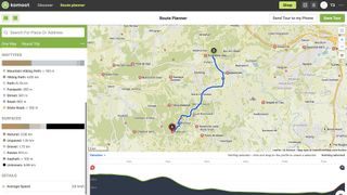
Hiking with Komoot: same journey, totally different route
Here, the route is completely different. Some Hikes, like some MTB trails, have a more in-depth rating system. The T scale ranks walks from T1 (trails) to T6 (‘Advance Alpine Hiking Trails). The home counties are a bit short of alpine trails, however, and anyway this route is again described as ‘Intermediate’ using Komoot’s own system.
Travelling on foot is a great way to take advantage of Komoot’s Highlights. Komoot is a community and social network as well as an app, and as part of it you can view other users; Highlights and create your own. You can write accounts of your latest adventures and take photos that can be shared via Komoot for others to enjoy, and inserted into your route maps.
If the route planner is giving you a crisis of too much choice, there is also the option to use Komoot’s Discover service. This has a wealth of routes suggested by the Komoot community that you can follow or adapt. You can adjust them via a Difficulty filter and there’s also an invaluable time slider then lets you adjust the route to suit the number of hours left in the day.
Komoot is not about performance, although it should help improve yours, and it’s not about navigation per se, although it will prevent you getting lost with on-phone, offline maps and voice directions. What it’s about is exploring what the world has to offer cyclists, hikers and trail runners.
Getting started with Komoot
You can use both the Komoot app – it's available for iOSand also for Android – and the Komoot website.
The latter gives you more screen real estate to plan your trip, on a laptop, but the app has all the same core functionality, and opens a world of adventure with an incredible degree of personalisation.
Just register and download the Komoot app to plan routes and follow them in the wild.
Komoot is a community-based outdoor mapping system based on Open Street Map. Using it, you can follow routes chosen by users, or Komoot’s own team. You can also share your own adventures with routes, photos and Komoot Highlights (points of interest). It’s the smarter way to get outdoors and do more of what you love.


